Translate

08/30/14 Preston Park

Siyeh
My friends, Zach and Mandy, came out from Colorado for a visit and we drove up to Glacier  National Park to do some hiking.  On the 30th of August we started out from Siyeh Bend and climbed up the switchbacks and to the second trail junction.  Our main objective for the trip to Glacier was Floral Park for the next day, but at the junction of the Piegan Pass and Siyeh Pass Trails you can tell you are close to really great and open views.  It's not that the views are bad lower down, but as you hike it is clear that it opens up just a little higher.  Zach had been to the park before, but Mandy hadn't, so I wanted to show them some of the best Glacier has to offer.  I was able to convince myself that Preston Park was a little closer than it actually was and then convinced them we should carry on to that point.

Following the creek
The views up to Siyeh and Matahpi were pretty incredible as we climbed into Preston Park from the junction.  The trees seem to grow smaller and are less crowded as the trail enters the park.  We followed the trail further, stopping at a small pond, until we came to a small creek that crossed the trail.  At this point, we left the trail and followed the creek past sections of long slabs and little cascades.  At the top of the climb up the creek we came to the small lakes that lie in the basin.  Since we had exceeded the mileage Zach and Mandy were hoping for for the day, we decided to just enjoy the lower and smaller of the two lakes.  We felt the depth of the bowl we were in and strained our necks to take in the whole cliffy scene surrounding us.

Lake in Preston Park
Creek we followed
Piegan Mountain and Glacier and Reynolds (left)
After enjoying some time at the lake and taking many photos, we stayed at the same elevation of the lake and made our way back to the Siyeh Pass Trail.  We descended the trail back to the creek we followed and eventually down to the junction with the Piegan Pass Trail, enjoying spectacular views back to Piegan Mountain and Glacier with Reynolds behind.  Despite having done the trail quite a few times and being back to the two lakes as well, I was thoroughly enjoying myself and trying to take in everything.  I don't think, after twelve years in and around Glacier, that I would ever feel differently on a hike in Glacier.  Zach and Mandy were also enjoying themselves, and it was fun being around a Glacier first-timer.  From the junction, we easily made our way down the well-maintained trail back to the trailhead.  We were all excited for the trip the next day.

08/28/14 Unnamed 4862 #76

Unnamed 4862 from Miller Creek

There is not anything particularly exciting about Unnamed 4862.  As my peakbagging addiction has gotten worse over the years, I have found more and more ways to lengthen my lists of peaks I would like to climb while never shortening them.  One website in particular, Lists of John, has had a big influence in my lists growing, but it has also helped me to have some organization to my lists and given me goals within larger goals.  One of these would be to hike all the ranked summits in a particular quadrangle map.  For instance, Unnamed 4862 is just one of seven different ranked peaks in the Blue Mountain Quadrangle.  At the time of this climb, I had already climbed five other peaks in the quad.  By hiking Unnamed 4862 I would leave myself only one peak to climb to complete the quad.  (Peaks I had climbed in this same quad already in this challenge include Unnamed 6004 and Black Mountain—#29 and #30—and Unnamed 5787—#32.)

Looking back to Blue Mountain
There were other reasons I wanted to climb this peak, however.  For one, despite its low elevation, there seemed to be no real easy way to access the peak.  Secondly, this access had already led to me not successfully climbing the peak on an earlier attempt.  I had hiked once or twice out of the Motorcycle/ATV Trailhead on Blue Mountain in the hopes of finding a trail that would take me close to Unnamed 4862.  Instead I found trails that dropped into Hayes Creek and then up the next ridge, not really getting very close to the bottom of Deadman Gulch.  My map showed a road connecting to the trail down in Hayes Creek, and I decided to give it a try from there.  The bushwhack and route finding would be easier and shorter from Hayes Creek.  That was my plan.  When I found the road that led up the creek to the trail, I also found that there was no public access along the road.  In frustration I turned around and went back home.  I had to figure out another way.

Power lines on the route
My second attempt was slightly fruitful, although I was still unsuccessful.  I made it back to the Motorcycle/ATV Trailhead and started on the trail, heading into Hayes Creek.  Before I could descend very far, I saw a dog on the trail.  It was all by itself and wouldn't come to me at first.  I told it to go find its human and it ran off.  I turned and descended a little more only to find the dog had returned.  I walked back with it to the trailhead in hopes that the owner was there or near there.  When we made it there, we were alone.  At this point I was pretty invested into the dog, and I gave it some water and waited for the owner.  After some time, I decided to drive down to cell range, with the dog, and called the number on the tag from a lower trailhead.  Eventually I met up with the owner and reunited her with her dog.  She said that was only one of them, and did I have the other?  When I drove off to go home—the ordeal took long enough for me to not want to be finishing my hike in the dark—I wondered if she might not decide in the near future to invest in some leashes.

Finally, on the 28th of August, I made it out for a successful attempt on the summit.  Like the last one, I started at the Motorcycle/ATV Trailhead and dropped into Hayes Creek.  I climbed out the other side to the top of a small ridge and followed the trail down on what I thought was a short loop that would wrap back around to the ridge.  The trail does do that, but I also found another trail that left from a point on that loop and carried on close to the bottom of Deadman Gulch.  Near the bottom, but still a little above the small creek that sometimes flows there, a trail carried on down creek.  Here I left the trail and crossed over the small creek bed and through some brush as I climbed up the other side.  The forest was mostly open and the brush wasn't too thick working up to some power line towers.  At this point, I linked up with a network of roads.  From my map I could see that this road would take me close to the summit.
View of the summit from the road

I followed that road, which was maintained but didn't seem to get much use, all the way to the saddle just before the summit.  I left the trail and followed the gentle ridge up to the top.  Like I wrote earlier, this peak is not particularly special, and I will likely never climb it again, but it provided a fun adventure and some splendid views into the Missoula Valley and the surrounding peaks that I was getting to know so well.  I had an uneventful and enjoyable trip back to the trailhead.

Elevation gain: 2650'     Total gain: 138,500'

08/18/14 Unnamed 6934 and Unnamed 6756 #74 and #75

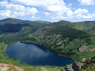
Pearl Lake with Unnamed 6934 in the distance
On the 18th we had another leisurely start to our day.  We made some breakfast, warmed ourselves in the sun, and then broke down camp.  Pearl Lake had been a great spot to camp.  We shouldered our packs and started along the lake to the climb I had made on the 16th.  It was certainly more difficult with a heavier pack, but the views were once again well worth the effort.  At the first, lower saddle, we had great views from the trail junction down into Dalton Lake.  The next steep push to the ridge had everyone grumbling a little and wondering how much they had gotten into this last day, especially after the day we had all worked so hard for the day before.  (This is how I ultimately end up losing hiking partners, and I've gotten better about it than I used to be, but I was pushing my luck a little with this trip in an attempt to get five peaks in on the trip and get to #75.)  Once we reached the ridge we sat down, had some snacks, and took in the views, and the grumbling stopped.  The top of the ridge is a beautiful sight, and we could trace our route most of the way to near Hoodoo Pass.
Top of the ridge with Unnamed 7256 in background

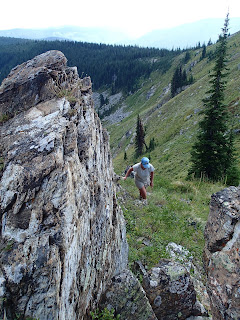
The walk along the ridge was as great as it looked.  There were views for miles and we could see from one peak to the next, following many connecting ridges to the next and next, in Montana and in Idaho.  This trail straddles the state line, passing from one state to the other and back again.  From many locations, our best views were along the Montana/Idaho line, heading northwest, but there were plenty of viewpoints where we could look back down on Pearl Lake or Heart Lake and sometimes both of them together.  Those views of the two lakes with the ridgeline we had walked the day before rising beyond sure gave some perspective to our backpacking trip in this little corner of the state.
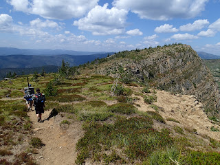
Ridge hiking

As we were rounding a hump on the ridge and descending slightly to a saddle from the Idaho side, we saw a goat ahead of us on the saddle.  It appeared to be alone, and as we approached further, the goat dropped off the ridge, down into Montana.  From where we were, it looked quite steep, but as we made it to the saddle we could see it was a short, mellow slope leading to the top of what was likely a steep snowfield—we could only see a patch and then the openness of a steep drop.  The goat was laying down on top of the snow, clearly trying to cool off as the day warmed on the open ridge.


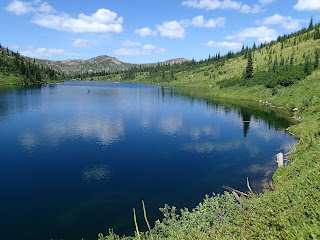
Heart Lake and Pearl Lake (upper right) and Lightning Peak (left)
Eventually the trail led to within fifty feet of the top of Unnamed 6934.  Here we stopped and talked about how we would like to end the hike.  I informed everyone that I hated to be selfish, but that I really wanted to finish out the ridge because I could run off and bag one more peak.  There was another option to descend from just beyond the peak we were on back down to Heart Lake and then the car.  Jake and Rhian were fine with Carrie and I hiking out the ridge, but weren't sure how they felt about hiking the ridge and more so how Ava would do with a dry, hot ridge.  We rested in the shade of a nearby tree and had a snack while we discussed the two options.  It took a little convincing, but Jake and Rhian decided to come along on the ridge.  It helped that Ava seemed ready to go when we stood up to look at the trail to the lake.

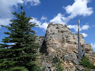
Rock outcrops near second summit of Unnamed 6934
This is what gets me in trouble, though.  I know how much I'm going to love something like the proposed ridge walk and think that everyone else will love it as much as I will.  I tend to forget the pains associated with some of these endeavors and only remember the joys.  (Jake and Rhian and I are still great friends and we have hiked since, but I was certainly pushing it.)  To make matters worse, a map I had showed the summit on the other side of the trail that descends to Heart Lake at the same elevation, or very near, as the peak we were on.  Of course I couldn't trust that they weren't exactly the same height or even slightly higher, and which one is the true highpoint?  I had to go over to it.  As we neared the junction with the trail down to the lake, I explained my predicament and that I needed to run off trail to get to the top of that summit as well.  Jake and Rhian were fine with that but wanted to keep hiking on the ridge.
Along the ridge to Unnamed 6756

Carrie and I stashed our packs near the junction in some trees and made our way up to the summit.  It was a fun little climb with some interesting rock formations.  On top I could not tell which summit was higher but was pleased that I had been on both.  The views were fantastic down to the two lakes as well as along further toward Hoodoo Pass.  We could see Jake and Rhian along the ridge and gave them a hoot and a wave, and then we dropped back quickly to our packs and down the trail, eventually catching them.  In about half an hour we came to a spot where I asked if we could take a rest.  Everyone was glad to do so, and I again pushed my limits.  I explained that there was a final ranked summit I wished to climb not far off the trail and estimated that I could be back in about half an hour.  Jake and Rhian were fine with the break and Carrie felt the need to come along to not miss any peaks (I think).  We broke through some trees lower down and then a ridge became more obvious.  It wasn't as easy to follow as I had hoped with large rocks in spots and thick overgrown sections in others.  We eventually found faint signs of a trail near the top and some signs of a possible old lookout (small) or other structure.  No structure was remaining, but some of the wire cables which held part of it down were evident.  Along with the faint trail, we guessed there had been an old lookout up there.  We touched the top, took in the views, and turned to get back to our friends.  It took a little longer than expected, but not by too much.

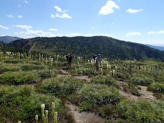
Beargrass ghost forest
We continued down the trail and wrapped through another amazing slope filled with dried beargrass stalks.  Beyond that we started descending toward Hoodoo Pass and hit the junction leading down the forested ridge to a trailhead closer to the one where we had parked.  We followed this trail down, catching some views through the trees down to Hoodoo Lake and passing the trail that headed there.  It was an easy-enough trail to follow and we descended to the road, where I assumed the role of car retriever, as was only fitting.  I left my pack with the others, taking only the keys and some bear spray, and jogged most of the two miles or so down to the car at the trailhead for Heart Lake.  I went and picked everyone up, and we had a pleasant ride to Missoula.  I would love to spend more time exploring in this area, especially a little to the south of where we were to climb Crater Mountain and Straight Peak.  Some day.

Elevation gain: 1880'     Total gain: 135,850'

08/17/14 Unnamed 6900 (S), Lightning Peak 7380', and Quartz Benchmark 7770' #72 and #73

Well it has been some time since I've updated this blog, but it is something I've always wanted to complete.  I will update when I'm able to so as to track all 100 summits during this one-year challenge.

Jake, Rhian, and Ava coming off Unnamed 6900
Saddle below Lightning Peak
On the 17th we woke leisurely, had some breakfast, and made a pretty good start in the morning on our way toward the main summits of the trip.  We walked briefly up Pearl Lake in the same direction I had gone the evening before.  After a short distance we decided to leave the trail and just head straight up the slope on our way to the ridge.  Jake and Rhian's dog, Ava, was not very excited about leaving the trail, and it took some coaxing to get her to join us on our off-trail adventure.  The slope was steep with old stalks of beargrass turning to seed and other flowers near the end of their bloom.  We worked our way up through the beargrass and sparse forest to the top of the ridge, and once on top we could see that we were a short distance from a highpoint on the ridge.  It was worth the slight detour to the top of that summit.  Upon returning home and reviewing a map and a peakbagging website I realized this summit gets a "Soft" rank, which means it falls below the 300' mark to be considered its own ranked peak, but because the summit has 280 feet of prominence, it is considered too difficult to determine its prominence exactly in terms of that 300' mark as the contour lines are 40' at best and sometimes larger.  This means that some of these "Soft" ranked peaks could potentially be within that 300', but at 280' this summit probably doesn't make it on that degree of error.

Ridge up Lightning Peak
Either way, the summit provided great views of the ridge we would follow to Lightning and beyond to Quartz Benchmark.  The walking along the ridge was easy and mostly open.  Occasionally trees would be growing thicker on the first section of the ridge, but a trail could be found sometimes off the ridge in the forest and sometimes it followed the ridge directly.  As we neared the hump before Lightning, the forest became more dense and the going became more tedious.  As the goal was Lightning, which was to the north, we were drawn in that direction in an attempt to cut off the top of the rounded hump and save distance.  This didn't necessarily work out in our favor.  We found cluster after cluster of fir that seemed more impenetrable than the last.  It's at these points where I start to apologize to the others as the plan was mine to go way out to these summits.  On the way back the old trail was a bit easier to find and follow and did lead closer along near the ridge.  Don't be tempted to cut off too much of this rounded hump.

Ridge walk to the true summit of Quartz
Near the saddle between the hump and Lightning Peak there is a beautiful meadow.  The grass was green and tall, and we enjoyed a part of the walk where we could go in any direction we pleased, especially after bashing through the trees.  From the meadow at the saddle there is an open forest that leads upslope to the ridge of Lightning.  Out on the ridge it is pretty open and the flowers were blooming.  We had some wonderful views off toward Quartz, which seemed to be quite a ways away.  We pushed up the open slope and eventually made it to the summit of Lightning Peak.  We found some shade to rest in and to help Ava cool off, and we had a nice lunch with great views from the summit. 

View from near summit with Saint Patrick Peak on right
The summit of Quartz appeared to be still quite some distance from Lightning.  Jake and Rhian were wanting to get down to French Lake to do some fishing while Carrie and I hiked out to Quartz, so we all hiked down the north ridge on the trail and followed it into the amazing basin below Lightning's summit and beyond to the first small saddle.  Jake and Rhian left us at this saddle and started down toward the lake on what appeared to be a faint trail.  It turned out that it was likely an animal trail, and it disappeared into thick brush well above the lake.  This eventually turned them around as we were all a long way from camp at Pearl Lake.

Walking on the open ridge

Beyond the little saddle where we left Jake and Rhian, the trail suddenly became the most clear and obvious it had been all day.  This lasted for quite some time as we ascended but deteriorated, in small sections at first and then in larger and larger stretches, as we climbed higher and the forest thinned out.  Eventually we reached a highpoint and could see over top of the mountain.  It still looked further away than I had expected.  This is a long hike, and we weren't even to the turnaround summit yet.  The afternoon grew longer and yet the weather remained perfect with sun and a few lazy clouds.  There was no trail near the top of the highpoint we were on and beyond to the true summit, but the ridge walk was very enjoyable with great views to the north and west.


Carrie and I shared the summit with thousands of lady bugs and enjoyed the weather and the views along with having attained the highest point in Mineral County.  We contemplated how long the walk back to camp was going to be and wondered about Jake and Rhian's adventures down at the lake.  Eventually we reluctantly stood up and tried to crush as few lady bugs as we could as we left to retrace our steps back toward Lightning Peak.

Unnamed hump (right), Lightning (left), and Quartz (left center)
The walk back was pleasant but long.  We stopped up in the shade near a small snowbank up in the Lightning Peak basin before making the final push up to the peak.  We sat and enjoyed some water, made colder with some freshly-scooped snow in our bottles, while we took in the beauty of the upper basin.  Rocks were perfectly laid and lined with flowers and grass, which, with the snow, gave us a small alpine feeling.  We found that the later in the day it became, the harder it was for us to leave our resting places, and we could have stayed in that upper basin forever.  For a bit we had wondered if we would see Jake and Rhian on their way back from French Lake.  After a ten minute break with no sign of them, the day not getting any shorter, and camp not getting any closer, we figured they were well on their way to camp and followed after them.

Pinnacle on cliff face with view back to peaks
The climb up Lightning was a grunt but worth it again for the view.  It was a quick drop on the open ridge back down to the saddle, where I spotted the trail heading off closer to the ridge of the unnamed hump than where we had first come to the saddle.  We followed this faint trail and it avoided all the thick growth we had encountered on the way out and led us to the open forest on top of the ridge before tapering out.  It was pleasant hiking along this ridge, and we made a final short climb toward the first highpoint we had climbed that day.  Instead of ascending it again we found a way around the north side that gave us nice views of a small pinnacle on a cliff face.  Near the cliff face there was a trail we followed, but it too eventually faded away in the beargrass on the face above Pearl Lake.  At one point we spooked up a deer that we saw jump once or twice, but if it was not jumping, its body was out of view in the thickest beargrass stalks I had ever seen.  We bashed our way through this beargrass ghost forest down to the lake and Jake and Rhian and camp.  They cooked a great meal that night and we were all in bed earlier than we had been the night before.

Elevation gain:  4050'     Total gain:  133,970'


08/16/14 Unnamed 7256 #71

Hiking around Heart Lake
On the 16th, I drove west of Missoula with Carrie, Jake, and Rhian.  We started a backpacking trip from the Heart Lake Trailhead.  It was a very nice trail up through lush forest to Heart Lake.  Views were nice in spots heading up to Heart Lake, but they became better once we reached the lake.  We encountered some other backpackers who were heading out and offered us their spot.  We had planned on hiking further--past Heart Lake to camp at Pearl Lake.  We saw one or two other groups camping around the lake as we continued to hike.  As we began to climb away from Heart Lake, it began to rain a bit.  Fortunately it did not last long and we pushed on to Pearl Lake.  Heart Lake had been beautiful, and Pearl Lake was even more impressive.

Near the Pearl Lake camp

We found a spot to set up camp a little past the middle of the lake.  We set up our tents and found a way to get up a food hang and then we relaxed.  Jake wanted to go fishing and Carrie and Rhian decided to go pick huckleberries near the foot of the lake.  I had pushed for this trip to have a shot at climbing five peaks in the whole trip and I had figured I needed to climb the first peak on the first afternoon.  It was going to be one of the harder sells to get the rest of the group to climb this random, unnamed hump in the middle of nowhere and in the opposite direction we would need to hike on the last day, so I figured I could hike up it and be back down in time to help cook dinner.

Dalton Lake
I left camp and followed the trail along the lake and then as it climbed beyond the head of the lake.  The trail was a bit steep, but it had some switchbacks that made it more bearable.  At the first saddle I found the trail that headed down to Dalton Lake as well as great views to that amazing lake nestled in below an impressive, cliffy ridge.  From the saddle, I followed steep trail that climbed toward the crest of the ridge and the Montana/Idaho border.  Eventually it quit climbing so directly and did a nice ascending traverse toward the ridge.  Once on top, I took in the great views.  Looking northwest, it was exciting to see the route we had planned to hike out along that ridge.  Equally exciting were the views toward the summit of the peak.  From the lower saddle I had thought the true summit was at the end of the ridge over Dalton Lake, but from the ridge it was obvious that the true summit was a more-mellow walk, mostly along trail, to the top.

The ridge that the trail followed for our hike out
I left the trail to stay on the ridge and save some backtracking.  Before reaching the final saddle I picked up the trail and found it very pleasant to follow it to the top of the peak.  While it may have not been the most stunning peak from the direction I had climbed it, it did provide some stunning views.  Looking east toward Crater Mountain and beyond to the south worked to greatly increase the number of peaks on my list of ones I would like to climb.  I stood on an outcrop of rock over a small patch of snow and had quite the perch over the Trio Lakes.

Two of the three Trio Lakes and Crater Mountain
After snapping some photos and trying to memorize the new and beautiful scenery, I decided to head back so as not to be late to cook dinner.  The descent back to the first saddle was quick along the trail.  I again decided to leave the trail so as to stay on the ridge and save some time.  Once back on the trail I descended quickly back to Pearl Lake and camp.  I made it back in time to help Carrie cook some dinner, and we sat up into the dark and starry hours enjoying the evening and each others' company.


Evening on Pearl Lake
Backcountry dinner


Elevation gain:  2600'     Total gain: 129,920'